Deadly Typhoon Wipha Slams Japan

A weather map of Typhoon Wipha.

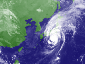
Deadly Typhoon Wipha is a once in a decade storm.

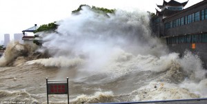
As if Japan needed another natural disaster, Typhoon Wipha just passed over the island of Izu Oshima, south of Tokyo, bringing strong winds and 80 cm (31 1/2 in) of rain in merely 24 hours.

Fourteen people have been killed in landslides, so far, and houses have been buried or completely destroyed, and many more are unaccounted for.

Now, watch Tokyo and Fukushima as Wipha tracks north.

Once In A Decade Storm

The Japan Meteorological Agency reported the storm as the most powerful in ten years, and the amount of rain has surpassed their records, which date back to 1991. 122 mm (5 in) of rain fell in just one hour on Wednesday morning.

After passing Izu Oshima, 20,000 people were ordered to evacuate as the typhoon approached Japan and the storm moved northward over the mainland of Japan.

Deadly Landslides

Due to landslides, rescue efforts are hampered on Izu Oshima. Affected areas are difficult to reach and search. Almost 300 homes have been destroyed on the island, and the full extent of the damage is still being assessed.

Updates from International Charter: Space and Major Disasters

Cyclones Hitting Earthquake Areas

The powerful tidal wave in China.

Powerful storms are coming ashore in India and the Philippines.

India and the countries along the Indian Ocean have had their fair share of natural disasters from earthquakes and tsunamis, and the Philippines have had every natural disaster hit their island from volcanoes, earthquakes, and violent storms.

Today, violent cyclones (aka hurricanes) are coming onshore in both of these countries.

Typhoons, Cyclones, Tropical Storms and Hurricanes

A map of the Bay of Bengal

Tropical cyclone Phailin formed in the enclosed Bay of Bengal

Tropical cyclone Phailin has whipped up hurricane force winds equal to a CAT 4-5 hurricane. Forming within the enclosed Bay of Bengal, Phailin came onshore in India October 12, 2013. So far, 800,000 people have been evacuated from this very highly-populated eastern Indian shore.

Typhoon Nari crossed over the northern region of the Philippines in Luzon on October 11-12, 2013, Thirteen people were killed when the storm ripped off the roofs of homes and buildings, toppled trees, and triggered flash floods and landslides.

Nari is now in the South China Sea heading directly toward VietNam, and is expected to make landfall early Sunday October 13, 2013.

Typhoon Wipha  has formed in the Pacific Ocean, east of the  Philippines, and is heading NNW toward the southern islands of Japan.

Tropical Storm Octave is forming south of Baja, heading north onto the Baja Pensisula, but no warnings have been issued.

What’s A Cyclone?

The terms “hurricane” and “typhoon” are regional names for a strong “tropical cyclone”;  they are all the same thing – a violent storm that forms over water.


The Calm Before The Storm – Where Are All The Hurricanes?

A Nasa satellite picture of Hurricane Ike in 2008.

The 2013 hurricane season has been very quiet – too quiet.

There is little doubt that rare, tropical storms are now forming in odd places, like in the Mediterranean Sea, and due to their rarity, they have not been studied in the past.

The intensity and frequency of rainfall in Central America has now increased to the point that swollen rivers are flooding areas that seldom witness this type of devastation. In August 2013, historic snowfall blanketed one of the driest places on Earth, the Atacama Desert in South America.

The world is experiencing historic and very strange violent storms with little understanding of why they are occurring. As a result of this strange weather, a stormy hurricane season was predicted. So, don’t you wonder what happened to the hurricanes this year?

The Calm Before The Storm

As the Earth warms, more energy in the ocean leads to stronger storms. As residents of the Gulf of Mexico and on the Atlantic coast know well, severe storms over the past five years have become more extreme.  But, this 2013 hurricane season has been the opposite – no major hurricanes have formed – yet – and the season has been eerily calm.

This is good in one way, and very disturbing in another. This isn’t natural, and feels like a dangerous calm before a big storm …

Increase In Hurricanes

The destructive power of hurricanes has increased since the mid-1970s when the most rapid increase in global ocean and land temperatures became more noticeable. With the exception of this 2013 hurricane season, the number of severe hurricanes has doubled worldwide, and the increase in major storms like Hurricane Katrina in 2005 coincides with a global increase of ocean temperatures.

This temperature increase is part of a long-term climate shift mixed with the rise in volcanic eruptions that will continue to persist for several more decades.

From Katrina To Ike

In 2005, Hurricane Katrina was one of the five deadliest hurricanes in the history of the United States, and the sixth strongest hurricane recorded in Atlantic Ocean history.

Following less than a month after Hurricane Katrina devastated large parts of the central Gulf Coast region, Hurricane Rita was the second hurricane of the season to reach Category 5 status in the Gulf of Mexico. One of the strongest storms on record, Rita peaked sustained winds of 175 mph.

This marked the first time that two hurricanes reached Category 5 strength in the Gulf of Mexico in the same season, and only the third time that two Category 5 storms formed in the Atlantic Basin in the same year.

Then came Ike three years later. Hurricane Ike was the largest hurricane ever observed in the Atlantic basin and the third most destructive hurricane to make landfall in the United States.

It’s far too quiet in the Atlantic. No hurricanes are forming, and THIS is worrisome. When the next hurricane DOES form, it might be a doozy.