Tropical Storm Flossie + Small Earthquake Hits Oahu, Hawaii

NOAA satellite image of Tropical Storm Flossie.

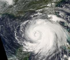
Tropical storm Flossie packs a direct hit onto the Hawaiian Islands – NOAA.

Talk about a double whammy. A tropical storm warning is in effect for the Windward Coast of Oahu just after it experienced a small 3.5 magnitude earthquake today, Monday July 29, 2013.

The good news – no tsunami warning is out, but a flash flood watch is issued through late Tuesday night along the main Hawaiian Islands.

Tropical storm Flossie is weakening as it impacts Hawaii, but its torrential rains are dangerous as the storm hits the island of Oahu. It is the first tropical cyclone to make landfall on the Hawaiian islands since 1992, and it’s a direct hit.

Lots Of Rain

Satellite image of Tropical Storm Flossie

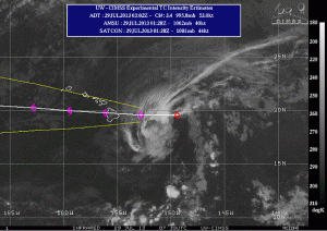
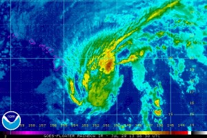
Satellite image of Tropical Storm Flossie taking a direct hit onto the Hawaiian Islands, July 29, 2013.

The storm is expected to bring 6 to 10 inches of rain over Maui and the Big Island, with up to 15 inches possible in isolated locations, and 4 to 8 inches of rain over Oahu and Kauai, with isolated maximums of up to 12 inches possible.

Sustained winds up to 45 miles per hour are expected, and a “dangerously high surf” is already hammering eastern-facing shores of the Big Island, and will soon spread to the other islands and continue through Tuesday.

The entire state is under a tropical storm warning and a flash flood watch through Tuesday night.

I wish everyone a safe “next couple of days.” … and NO SURF’s UP, guys.


A Is For Tropical Storm Andrea

A Nasa satellite picture of Hurricane Ike in 2008.

2013 hurricane season begins June 1.

Tropical Storm Andrea, the first official storm of the Atlantic season, made landfall in Florida, Thursday, June 6, 2013. Georgia residents are preparing for high winds and heavy rains, and Andrea’s biggest threat in the Carolinas will be heavy rain, with as much as 6 inches expected. What remains of Andrea will continue to move north up the East Coast, Friday and Saturday.

2013 Hurricane Season

NOAA is forecasting an extremely active season this year. The six-month hurricane season begins June 1, and NOAA’s Atlantic Hurricane Season Outlook says there is a 70 percent likelihood of 13 to 20 named storms (winds of 39 mph or higher), of which 7 to 11 could become hurricanes (winds of 74 mph or higher), including 3 to 6 major hurricanes (Category 3, 4 or 5; winds of 111 mph or higher).

Get your rain gear ready.


Hurricane Barbara Floods Mexico

The NOAA map of Hurricane Barbara

Hurricane Barbara hits Central America, May 29, 2013 – NOAA (click to enlarge)

Following Tropical Storm Alvin, Hurricane Barbara, the second storm of the eastern Pacific hurricane season, crashed ashore along Mexico’s southern Pacific coast, Wednesday May 29, 2013. A hurricane warning is in effect for Puerto Angel to Barra De Tonala Mexico, and a tropical storm warning is in effect for Barra De Tonala to Boca De Pijijiapan Mexico.

Barbara is expected to dump between 6-10 inches of rain over eastern Oaxaca and western Chiapas, with up to 20 inches possible in southeastern Oaxaca causing flash floods and mudslides.

A picture of a deadly landslide in Ecuador on january 24, 2013.

Deadly landslide in Ecuador on January 24, 2013.

During the last seven days, a significant increase in rainfall was received throughout Central America, Costa Rica, Panama, and parts of Guatemala.

Global Flooding

Floods are blanketing the globe, actually, and the following countries/states are under current flood warnings:

Hawaiian Islands

Central America

England

Germany

Norway

Middle Mississippi River Valley

Malaysia

Alaska

Bahamas

North Dakota

Texas