Earthquakes Increasing In Number And Intensity

A picture of the Earth with an earthquake crack going down the USA and S America

We’ve had another increase in earthquake intensity and tsunamis.

This was an active earthquake week, with a few small tsunamis thrown into the mix. The following quakes shook the Pacific Rim  and the Caribbean, 5/10 through 5/16, 2014:

  1. 5.6  Alaska  5/10
  2. 5.3  Off Oregon Coast  5/12
  3. 6.5  Southern East Pacific Rise  5/12
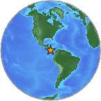
  4. 6.8  Panama  5/13
  5. 6.6  Yap  5/14
  6. 6.6  Yap  5/15
  7. 6.2  Philippines  5/15
  8. 5.7  New Caledonia  5/15
  9. 6.0 Antigua and Barbuda  5/16 –  local tsunami  Leeward Islands Caribbean Sea
  10. 5.0  Guadeloupe  5/16
  11. 5.5  Chile  5/16
  12. 5.0  Indonesia  5/16
  13. 5.1  Saint Helena

Large Earthquakes Continue To Rock The Pacific, Generating More Tsunamis

A picture of a temperature thermometer that says problem, emergency, crisis, disaster.

More large earthquakes have occurred near the Solomon Islands, generating a 4th tsunami warning.

Over the past 24 hours, large earthquakes have continued to shake the Pacific Rim, sending out more tsunami warnings.

A 4th tsunami warning for the Pacific Islands was issued after a 8.3 magnitude quake struck at Kirakira, Solomon Islands 23 hours ago. Since my last post, April 10, 2014, the following quakes have occurred:

  1. 5.3  Iquique, Chile (offshore)
  2. 8.3  Kirakira, Solomon Islands (tsunami warning issued for Pacific Ocean)
  3. 7.7  Kirakira, Solomon Islands
  4. 5.7  Kirakira, Solomon Islands
  5. 5.6  Kirakira, Solomon Islands
  6. 5.3  Papua New Guinea
  7. 5.9  Kirakira, Solomon Islands
  8. 5.0  Kirakira, Solomon Islands

When an earthquake occurs, I record the initial magnitude reading from the Pacific Disaster Alert Center in Hawaii. You will notice that USGS typically lowers these magnitudes, but I maintain that the initial seismograph reading is the most accurate.

A tropical beach with clouds raining over it.

Several large earthquakes have caused tsunami flooding along the Pacific island coasts.

Sea level readings did indicate that a tsunami was generated along the coasts near the earthquake epicenter. If damaging waves subside after two hours of the quake, local authorities can assume that the tsunami threat has passed. A danger to boats and coastal structures remains for several hours after a large quake due to rapid currents.

You won’t hear much about these tsunamis on US mainstream news, but they are very important to the people living in these island regions.

Third Tsunami Watch Issued Within 24 Hours

USGS small Earth globe showing Nicaragua

Central America is continuing to experience some very large earthquakes.

After my last post merely hours ago, another tsunami watch has gone out – the third in 24 hours.

Latest Quakes

  1. 5.0  Visokoi Island (South Atlantic/Antarctica)
  2. 5.6  Papua New Guinea (Solomon Islands)
  3. 6.6 Nandaime, Nicaragua (on-ground)

Tsunami Watch

Luckily, a tsunami was not generated from this quake, primarily because the 6.6 quake occurred on the land, but high waves will be generated within the Pacific.

With the number of large quakes taking place within such a short time span, Hawaii, the Galapagos, and many Pacific Islands should expect high waves, strong rip currents, and some flooding.