First Winter Storm Comes Early

 huge bolt of lightening.

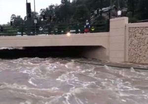
An early winter storm is heading into the central US bringing a mix of snow and severe weather.

The first winter storm, Atlas, is driving down into the northwestern part of the US Thursday and Friday. Temps are expected to drop all the way south into Texas, dropping as much as 30 degrees, and severe storms are expected throughout the Midwest.

Global Warming Actually Means Global Cooling

Snow and colder temperatures in October? Isn’t this a bit early?

Yes, but we have all noticed that the weather has been unpredictable and very odd over the past three winters. This might seem confusing with the “global warming” debate going on, but global warming actually means global cooling at the end of the day.

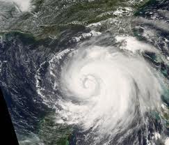
There is no doubt that our planet is heating up, but the atmosphere is also filling up with lots of “stuff” – carbon from wildfires and volcanic ash, carbon dioxide from human pollution,  metals such as aluminum, barium and strontium from weather modification, and changes in sunlight.

As the atmosphere fills with gases and particulate matter/junk, it retains more heat at the Earth’s surface, which heats us all up. At the same time, the heat coming in from the Sun is reflected back into space, and this creates a chain of events that brings odd weather because it knocks the Earth’s natural thermostat out of whack.

This creates the following chain of events:

  1. global warming creates more evaporation from the oceans; hence, more rain and storms;
  2. planetary heating melts the polar ice sheets and continental glaciers; hence, more rain and floods;
  3. as the planet continues to warm, more storms and rain occur in the Spring, Fall, and Summer seasons, and more snow and ice in the Winter, Spring and Fall;
  4. chronic global warming creates chronic storms occurring earlier and lasting longer, year by year.

Like today, October 3, 2013.

Mini-Ice Age

A picture of the ice melting in Antarctica

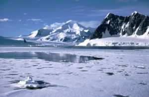
Arctic ice is melting at the same time it is beginning to refreeze due to a Mini-Ice Age..

Humans  have never witnessed the climate changes and the sheer number of natural disasters that we are experiencing today. Measurements taken from ice cores and sea-floor sediments show definite trends in the Earth’s climate; that trend is to expect a mini Ice Age within the next 10 years.

Understanding that climate change is a natural cycle that humans cannot control helps explain the mysterious coming and going of the odd weather patterns today.

Climate changes have a very precise pattern, and the timing of these cycles is determined by changes in sunlight, in the Earth’s rotation and orbit around the Sun, and in the amount of particulate matter present in our atmosphere – “stuff” put there by both man and Nature.

All these influences are changing our weather patterns. it’s time to get your winter sweaters out, but don’t put your shorts and sandals away, yet.


From Drought To Floods In Colorado

Rising water under a bridge in Evergreen, Colorado.

Floodwaters continue to rise in Evergreen, Colorado after days of heavy rain – and it’s still falling.

As of Thursday afternoon, September 12, 2013, Boulder, Colorado had received a record-breaking 9.6 inches of rain, and it is still falling.

Damaging floods in and around Denver, Boulder, Colorado Springs, and some isolated towns in the foothills of the Rockies have been inundated with flash flooding.

The state has not experienced a “100-year flood” like this since 1894.

Fires and Development

Wildfires in the mountains over the past few years have not yet grown back, and this has left large burn areas in the canyons that are at a very high risk for flash-flooding and wash-outs.

Barren terrain results in fast runoff, and this increases flood and landslide hazards downhill. And, what’s downhill? – housing developments, concreted streets, bridges, and strip malls.

More To Come?

Rain is forecast to continue in the area through Saturday, so this event is, sadlyfar from over.

The Calm Before The Storm – Where Are All The Hurricanes?

A Nasa satellite picture of Hurricane Ike in 2008.

The 2013 hurricane season has been very quiet – too quiet.

There is little doubt that rare, tropical storms are now forming in odd places, like in the Mediterranean Sea, and due to their rarity, they have not been studied in the past.

The intensity and frequency of rainfall in Central America has now increased to the point that swollen rivers are flooding areas that seldom witness this type of devastation. In August 2013, historic snowfall blanketed one of the driest places on Earth, the Atacama Desert in South America.

The world is experiencing historic and very strange violent storms with little understanding of why they are occurring. As a result of this strange weather, a stormy hurricane season was predicted. So, don’t you wonder what happened to the hurricanes this year?

The Calm Before The Storm

As the Earth warms, more energy in the ocean leads to stronger storms. As residents of the Gulf of Mexico and on the Atlantic coast know well, severe storms over the past five years have become more extreme.  But, this 2013 hurricane season has been the opposite – no major hurricanes have formed – yet – and the season has been eerily calm.

This is good in one way, and very disturbing in another. This isn’t natural, and feels like a dangerous calm before a big storm …

Increase In Hurricanes

The destructive power of hurricanes has increased since the mid-1970s when the most rapid increase in global ocean and land temperatures became more noticeable. With the exception of this 2013 hurricane season, the number of severe hurricanes has doubled worldwide, and the increase in major storms like Hurricane Katrina in 2005 coincides with a global increase of ocean temperatures.

This temperature increase is part of a long-term climate shift mixed with the rise in volcanic eruptions that will continue to persist for several more decades.

From Katrina To Ike

In 2005, Hurricane Katrina was one of the five deadliest hurricanes in the history of the United States, and the sixth strongest hurricane recorded in Atlantic Ocean history.

Following less than a month after Hurricane Katrina devastated large parts of the central Gulf Coast region, Hurricane Rita was the second hurricane of the season to reach Category 5 status in the Gulf of Mexico. One of the strongest storms on record, Rita peaked sustained winds of 175 mph.

This marked the first time that two hurricanes reached Category 5 strength in the Gulf of Mexico in the same season, and only the third time that two Category 5 storms formed in the Atlantic Basin in the same year.

Then came Ike three years later. Hurricane Ike was the largest hurricane ever observed in the Atlantic basin and the third most destructive hurricane to make landfall in the United States.

It’s far too quiet in the Atlantic. No hurricanes are forming, and THIS is worrisome. When the next hurricane DOES form, it might be a doozy.