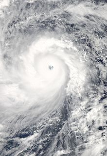
Super Typhoon Haiyan devastates the Philippines – NOAA
Never before in human history have we seen so many natural disasters hit one area – over and over again.
Many islands in the Philippines are in total ruin, and hundreds of thousands of people have been devastated by continuous natural disasters.
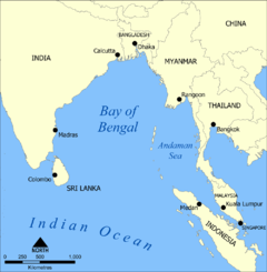
7,000 Islands
Its location on the Pacific Ring of Fire close to the equator makes the Philippines prone to earthquakes and typhoons.
And don’t forget to throw in a volcano or two.
The Philippines is actually an archipelago of 7,107 islands that are within three main geographic divisions:
- Luzon
- Visayas
- Mindanao.
With a population of more than 98 million people, the Philippines is the seventh-most populated country in Asia.
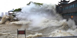
Typhoon Haiyan
Typhoon Haiyan (known in the Philippines as Typhoon Yolanda) is the strongest recorded tropical cyclone to ever make landfall, with wind speeds up to 315 km/h (195 mph).
On November 4, 2013, the tropical storm began to intensify to typhoon levels. By November 6, the typhoon had magnified into a super typhoon equal to a Category 5- hurricane as it passed over the island of Kayangel.
Haiyan continued to intensify as it made landfall. Gradually weakening, the storm made five more landfalls before reaching the South China Sea. Over 720,000 people were forced to evacuate their homes.
Typhoon Haiyan leveled Samar Island and Leyte, where at least 10,000 people in the city of Tacloban alone are reported dead. Turning northwest, Haiyan struck northern Vietnam as a severe tropical storm on November 10.
Next Is Typhoon Zoraida
The world will be closely watching the next typhoon, Zoraida, that appears to be going on the same track as Haiyan. Still a Tropical Depression, Zoraida is the 25th cyclone to enter the Philippine archipelago this year. It made landfall in Cagayan, Davao Oriental Tuesday morning, November 11, 2013.
Several areas within the Philippines have been placed under Public Storm Warning Signal Number 1. Zoraida is packing maximum winds of 55 kp/h (34 mph). This cyclone is not as powerful as Haiyan by any stretch, but high waves and flooding will impact an already saturated region.
Earthquakes
The Philippines is experiencing large earthquake activity today.
Typhoon Haiyan exacerbated the damage on Bohol Island from a 7.2 magnitude earthquake that killed 222 people merely three weeks earlier.
Over 270,000 people are displaced and homeless from the October 15 quake.
On November 3, 2013, a 6.0 magnitude quake struck SSW of Palimbang, Philippines.
And, then came Haiyan.

Mount Mayon Volcano in the province of Bicol, Philippines.
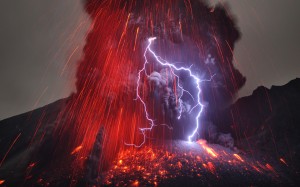
Volcanoes
Today, volcanic eruptions are increasing worldwide, and the Philippines is no exception.
Located on the Pacific Rim’s Ring of Fire, the Philippines sits on top of the world’s most active volcanic zones.
It is hard to label a volcano as “active” or “inactive” these days as earthquake and volcanic activity increases. There are 23 – 25 volcanoes within the Philippine archipelago, however, that are presently showing signs of volcanic activity.
Tsunamis
There have been no tsunamis to date, although several local tsunami warnings have been posted after large earthquakes have rattled this region in 2013. Let’s hope for the best on this one.
The Philippines has had its share of natural disasters in 2013.
Enough, right?