North And South Poles Are At It Again

USGS small globe showing the Bellany Islands off Antarctica

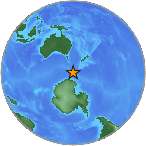
The Balleny Islands off Antarctica – USGS

There’s been some major movement at both the North and South Poles over the past two days, and the equatorial regions are now responding.

The Poles

On October 28, 2013, a 5.3 magnitude quake shook the northern Mid-Atlantic Ridge between Greenland and Iceland. Approximately six hours later, the Antarctic Plate responded with a 4.5 magnitude quake south of Africa off the Prince Edward Islands.

Two hours later on October 29, 2013, a 6.0 magnitude quake shook the Antarctic Plate between Antarctica and South America at the Balleny Islands.

Less than an hour later,  Leavenworth, Washington had a 3.3 quake, a small 2.5 earthquake rattled south of San Francisco, and Nikolski, Alaska had a 4.3 and a 5.0 magnitude quake an hour apart.

South America

USGS map of quake off Peru

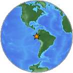
Recent quakes off the South American coast – USGS

After the 5.3 quake shook west of Iceland, the following quakes have occurred off the west coast of Central and South America:

  1. 2.8  Alberto Oviedo Mota, Mexico
  2. 4.3  Coquimbo, Chile
  3. 4.6  Ovalle, Chile
  4. 4.5  Chirilagua, El Salvador
  5. 5.0  Chivay, Peru
The USGS small globe showing the June 2013 earthquake in Papua New Guinea

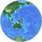
Quakes at Papua New Guinea – USGS

Japan and Indonesia

The following quakes have occurred in the western Pacific around Japan and Indonesia:

  1. 4.6  Papua, New Guinea
  2. 5.3  Papua, New Guinea
  3. 5.0  Japan
  4. 4.7  Kuripan, Indonesia
  5. 5.0  Fiji
  6. 4.3  Kendari, Indonesia
  7. 5.1  Fiji
  8. 5.2  Sarangani, Philippines

US and Alaska

  1. 3.0  King Salmon, Alaska
  2. 3.0  Fort Yukon, Alaska
  3. 3.3  Leavenworth, Washington
  4. 2.5  East Foothills, California
  5. 2.5  Lompoc, California
  6. 4.3  Nikolski, Alaska

Caribbean

The USGS small globe showing the Caribbean earthquake April 30, 2013.

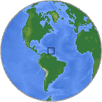
Caribbean earthquakes – USGS

  1. 3.0  Puerto Rico
  2. 2.8  Puerto Rico
  3. 3.1  British Virgin Islands
  4. 2.6  Puerto Rico

There’s a lot of movement all over the world right now. Watch for more activity off the US, Central American, and South American coasts.


14,000 Hiroshima Bombs Pointed At The Pacific

A black and white radioactive sign.

The radiation threat at Fukushima in November will be at catastrophic levels.

This is what is happening at Japan’s Fukushima nuclear reactor in November. The fuel removal from Reactor 4 will match the fallout of 14,000 Hiroshima bombs if something goes wrong.

I am not a gloom-and-doomer, but I am a realist, and the chances are high that the removal of over 1300 spent fuel rods from a malfunctioning fuel storage tank could go wrong.

These fuel rods hold enough radiation  to equal 14,000 nuclear bombs. If another accident occurs, radiation will spill into the Pacific Ocean, evaporate into the atmosphere, and will circulate all over the Northern Hemisphere – for decades.

The bring-down of the fuel rods from Fukushima Reactor 4 is the most dangerous engineering task ever undertaken in human history.

Two Weeks From Now

The damaged Fukushima nuclear reactor.

Reactor 4 at the Fukushima nuclear reactor is tipping and sinking into the ground.

As early as November 8, 2013 – the operation is due to begin. Reactor 4 is tipping and sinking, and will not withstand another large earthquake or tsunami like the 9.0 magnitude quake and tsunami that destroyed the nuclear power plant in 2011.

This operation is dangerous enough on its own, but what happens if another earthquake occurs, followed by a tsunami of any size, or if a typhoon smacks into the Japanese coastline?

Recent Earthquakes

On Friday, October 25, 2013, a 7.5 magnitude earthquake occurred about 200 miles east of Honshu, Japan, the location of the Fukushima nuclear reactor. A small tsunami watch was issued, but waves merely rose about 3 feet. The 7.5 quake was downgraded to a 7.1.

After the 7.5 magnitude quake (7.1 really??), this area has experienced the following earthquakes:

  1. 5.1  Honshu 10/25/13
  2. 4.8  Honshu 10/25/13
  3. 5.5  Honshu 10/25/13
  4. 4.9  Honshu 10/25/13
  5. 4.6  Honshu 10/25/13
  6. 4.7  Honshu 10/26/13
  7. 4.4  Ishinomaki, Japan 10/26/13 (about 40 mi from Fukushima)
  8. 5.5  Honshu 10/27/13
  9. 5.0  Honshu 10/27/13
A weather map of Typhoon Wipha.

Deadly Typhoon Wipha was a once in a decade storm.

Typhoons

Typhoon Wipha hammered Japan in early October, followed by Typhoon Francisco that passed close to the island on Saturday.

It is expected to take over one year to remove the spent fuel rods from Reactor 4 – I suspect the threat of another typhoon will be knocking on Japan’s door sometime between now and then.

This human disaster could result in massive destruction for all life on our planet if another natural disaster occurs at Honshu.

Sadly, all any of us can do is just wait and see …


Cyclones Hitting Earthquake Areas

The powerful tidal wave in China.

Powerful storms are coming ashore in India and the Philippines.

India and the countries along the Indian Ocean have had their fair share of natural disasters from earthquakes and tsunamis, and the Philippines have had every natural disaster hit their island from volcanoes, earthquakes, and violent storms.

Today, violent cyclones (aka hurricanes) are coming onshore in both of these countries.

Typhoons, Cyclones, Tropical Storms and Hurricanes

A map of the Bay of Bengal

Tropical cyclone Phailin formed in the enclosed Bay of Bengal

Tropical cyclone Phailin has whipped up hurricane force winds equal to a CAT 4-5 hurricane. Forming within the enclosed Bay of Bengal, Phailin came onshore in India October 12, 2013. So far, 800,000 people have been evacuated from this very highly-populated eastern Indian shore.

Typhoon Nari crossed over the northern region of the Philippines in Luzon on October 11-12, 2013, Thirteen people were killed when the storm ripped off the roofs of homes and buildings, toppled trees, and triggered flash floods and landslides.

Nari is now in the South China Sea heading directly toward VietNam, and is expected to make landfall early Sunday October 13, 2013.

Typhoon Wipha  has formed in the Pacific Ocean, east of the  Philippines, and is heading NNW toward the southern islands of Japan.

Tropical Storm Octave is forming south of Baja, heading north onto the Baja Pensisula, but no warnings have been issued.

What’s A Cyclone?

The terms “hurricane” and “typhoon” are regional names for a strong “tropical cyclone”;  they are all the same thing – a violent storm that forms over water.