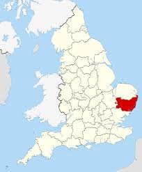
Another underwater discovery has been made; this time it’s off the coast of England. A medieval town has been identified as Dunwich, a thriving port in the Middle Ages. The town was located in the county of Suffolk on the Eastern coast of the United Kingdom. Much of the town is still identifiable, and has been surprisingly well preserved under the water.
The researchers discovered that Dunwich’s urban center once covered 0.7 square miles (1.8 square kilometers), an area about the size of London today. A defensive earthen wall was also discovered, possibly made by the Saxons, that enclosed the town’s central area.
This discovery is one of many underwater civilizations that have recently been discovered around the globe. Dunwich is a reminder of how quickly coasts can change as Earth changes increase.
A Thriving Medieval Port
At its peak, Dunwich was one of the largest ports in Eastern England, with a population of around 3000 people. Dunwich had eight churches, five houses of religious orders, three chapels and two hospitals. The main exports were wool and grain, and the main imports were fish, furs and timber from Iceland and the Baltic region, cloth from the Netherlands, and wine from France.
Climate change spawned its demise, and the thriving port of Medieval Dunwich was destroyed by Earth changes. It is suspected that major storms beginning in the 1268 swept the city out to sea and silted up the Dunwich River, choking off the Dunwich harbor. By the 1400s, Dunwich was obviously abandoned, and researchers speculate that over the centuries, the ruins continued to slip into the sea.
This may be the wrong assumption, however. After decades of shifting climate change (as we are witnessing today), the town probably experienced more flooding, violent storms, and temperature changes, but no one has considered the fact that its well-preserved remains show that Dunwich was swept into the sea quickly around the 1400s. If Dunwich had slowly dropped into the sea, this abandoned port town would have weathered much more than its artifacts show.
A sudden shift in the Earth’s rotation more than likely created the thriving town’s sudden demise, leaving the remains in tact, as they have been discovered today.
The Knights Templar
The Preceptory of the Knights Templar in Dunwich is thought to have washed away at this time. The Preceptory was established around 1189 and was a circular building ssimilar to the famous Temple Church in London today.
A little bit of history: when the sheriff of Suffolk and Norfolk took an inventory in 1308, the sum of £111 was found contained in three pouches – a vast sum of money for that day. In 1322, on the orders of Edward II, all the Templars’ land passed to the Knights Hospitallers. Following the dissolution of the Hospitallers in 1562, the Temple foundations washed away during this Earth shift.
Climate Change Causes Diminishing Coastlines
The lost port village has been difficult to explore because it sits beneath 10 to 33 feet (3 to 10 meters) of silt and muddy water. In 2008, researchers at the University of Southampton began an underwater survey of medieval Dunwich. In a new report, the team reveals recent, detailed maps of the town’s streets and buildings, including a chapel and the friary.
Today, global climate change due to shifting Earth cycles has made coastal erosion a topical issue of concern, but Dunwich reminds us that this has happened before. Dunwich serves as a reminder that modern humans MUST pay more attention to the upcoming Earth changes.
Modern civilization is dependent upon our major cities today. Metropolitan areas have become a depository for the technology that runs our modern world, and are the centers of highly concentrated populations.
If the Earth shifts today in a similar way to what happened to Dunwich, the destruction will be much more massive. If we are aware of this possibilty, and act upon it before it’s too late, we can better prepare to elude a major disaster.


