Medieval Village Discovered Off Coast of UK Warns Of Upcoming Earth Changes

A map of the UK painted with a British flag on the continent.

The UK

Another underwater discovery has been made; this time it’s off the coast of England. A medieval town has been identified as Dunwich, a thriving port in the Middle Ages. The town was located in the county of Suffolk on the Eastern coast of the United Kingdom. Much of the town is still identifiable, and has been surprisingly well preserved under the water.

The researchers discovered that Dunwich’s urban center once covered 0.7 square miles (1.8 square kilometers), an area about the size of London today. A defensive earthen wall was also discovered, possibly made by the Saxons, that enclosed the town’s central area.

This discovery is one of many underwater civilizations that have recently been discovered around the globe.  Dunwich is a reminder of how quickly coasts can change as Earth changes increase.

A Thriving Medieval Port
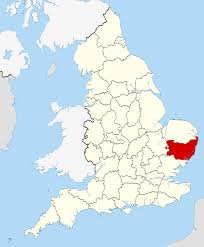
A map of Suffolk county, UK

Suffolk county, UK

At its peak, Dunwich was one of the largest ports in Eastern England, with a population of around 3000 people. Dunwich had eight churches, five houses of religious orders, three chapels and two hospitals. The main exports were wool and grain, and the main imports were fish, furs and timber from Iceland and the Baltic region, cloth from the Netherlands, and wine from France.

Climate change spawned its demise, and the thriving port of Medieval Dunwich was destroyed by Earth changes.  It is suspected that major storms beginning in the 1268 swept the city out to sea and silted up the Dunwich River, choking off the Dunwich harbor. By the 1400s, Dunwich was obviously abandoned, and researchers speculate that over the centuries, the ruins continued to slip into the sea.

This may be the wrong assumption, however. After decades of shifting climate change (as we are witnessing today), the town probably experienced more flooding, violent storms, and temperature changes, but no one has considered the fact that its well-preserved remains show that Dunwich was swept into the sea quickly around the 1400s. If Dunwich had slowly dropped into the sea, this abandoned port town would have weathered much more than its artifacts show.

A sudden shift in the Earth’s rotation more than likely created the thriving town’s sudden demise, leaving the remains in tact, as they have been discovered today.

The Knights Templar

The Preceptory of the Knights Templar in Dunwich is thought to have washed away at this time. The Preceptory was established around 1189 and was a circular building ssimilar to the famous Temple Church in London today.

A little bit of history: when the sheriff of Suffolk and Norfolk took an inventory in 1308, the sum of £111 was found contained in three pouches – a vast sum of money for that day. In 1322, on the orders of Edward II, all the Templars’ land passed to the Knights Hospitallers. Following the dissolution of the Hospitallers in 1562, the Temple foundations washed away during this Earth shift.

Climate Change Causes Diminishing Coastlines

The lost port village has been difficult to explore because it sits beneath 10 to 33 feet (3 to 10 meters) of silt and muddy water.  In 2008, researchers at the University of Southampton began an underwater survey of medieval Dunwich. In a new report, the team reveals recent, detailed maps of the town’s streets and buildings, including a chapel and the friary.

A picture of Tokyp, Japan, a major city built within a natural disaster zone.

Building major cities too close to changing coastlines

Today, global climate change due to shifting Earth cycles has made coastal erosion a topical issue of concern, but Dunwich reminds us that this has happened before. Dunwich serves as a reminder that modern humans MUST pay more attention to the upcoming Earth changes.

Modern civilization is dependent upon our major cities today. Metropolitan areas have become a depository for the technology that runs our modern world, and are the centers of highly concentrated populations.

If the Earth shifts today in a similar way to what happened to Dunwich, the destruction will be much more massive. If we are aware of this possibilty, and act upon it before it’s too late, we can better prepare to elude a major disaster.


Prehistoric Continents Discovered Off India And Brazil

icutre of Indian Ocean Vintage Map

Indian Ocean Vintage Map

On March 3, 2013, researchers found evidence of a landmass estimated to have existed between 2,000 and 85 million years ago.  The fragments of an ancient continent are buried beneath the floor of the Indian Ocean.

May 8, 2013, researchers announced that they found traces of a long-lost island/continent located at a high-rising mass of ocean floor about 930 miles offshore of Rio de Janeiro, Brazil.

A picture of a South American Vintage Map

South American Vintage Map

Surfacing Our Past

The continents that we live upon today are the archeological remnants of ancient continents, and are merely terrestrial artifacts formed from the fragments of the breakup of older supercontinents, long extinct.

Over the past 500 million years, there have been five different sets of continents, called supercontinents. Sometime in the future, there will be a sixth supercontinent very different from what we know today. All prehistoric continents began as one massive landmass, or “supercontinent.”

Supercontinent #1 – Vaalbara

The earliest known supercontinent was Vaalbara. Vaalbara is believed to have formed about 3,600 million years ago (3.1 billion years ago [3.1 GA]). The basic structure of Vaalbara consisted of eastern South African rocks that match the same rocks found today in the northwest section of Western Australia.

Supercontinent #2 – Kenorland

After Vaalbara, the supercontinent Kenorland was formed around 2.7 billion years ago. Kenorland formed what we know as today’s North America, Greenland, Scandinavia, Western Australia, and the Baltic regions.

Supercontinent #3 – Columbia

After Kenorland, the supercontinent Columbia formed around 2.0–1.8 billion years ago and broke apart about 1.5–1.3 billion years ago[i]. Columbia was small, about 12,900 kilometers (8,000 miles) from North to South, and about 4,800 km (3,000 miles) across its broadest stretch. Fossil records show that the east coast of India was attached to Western North America during this time, and Southern Australia was pushed up against Western Canada. Most of South America was positioned where the western edge of modern-day Brazil lined up with Eastern North America, extending to the southern edge of Scandinavia. The Amazon region in South America first appeared on Columbia[ii].

Supercontinent #4 – Rodinia

A picture of a dinosaur, which once roamed the Earth as humans do today.

The dinosaur disappeared after Rodinia.

After Columbia, the supercontinent Rodinia formed about 1.1 billion years ago, and broke up roughly 750 million years ago. This was a supercontinent that contained most of our present day landmasses, but geologic records show these continents were in an upside down world. Our present day continents were formed from the fragments of the breakup of Rodinia. 

Supercontinent #5 – Pangaea

Some 200 million years later, the broken pieces of Rodinia reconnected as Pangaea, and this was after the extinction that killed the dinosaurs.

Most of Rodinia was concentrated in the Southern Hemisphere, but the North and South poles had shifted at this time, pointing into the Sun. Pangaea was wrapped around the equator like a planetary belt. North America formed the core of Pangaea, called Laurentia, which was at the South Pole[iii].

The southeastern United States was wedged between Africa and South America. Australia, India, and Antarctica formed the largest landmass, called Gondwana, north of Laurentia.

Siberia, Russia was located just south of the equator between Gondwana and Laurentia, and Scandinavia, Europe, European Russia, and much of what is today’s Asia were in fragments along the north coast of Gondwana.

Supercontinent #6 – ????


[i] Zhao, Guochun; Cawood, Peter A.; Wilde, Simon A.; Sun, M. (2002). “Review of global 2.1–1.8 Ga orogens: implications for a pre-Rodinia supercontinent”. Earth-Science Reviews 59: 125–162.

[ii] Bispo-Santos, Franklin; Manoel S. D’Agrella-Filho; Igor I.G. Pacca; Liliane Janikian; Ricardo I.F. Trindade; Sten-Ake Elming; Jesué A. Silva; Márcia A.S. Barros; Francisco E.C. Pinho (June 2008). Columbia revisited: Paleomagnetic results from the 1790 Ma colider volcanics (SW Amazonian Craton, Brazil) Precambrian Research, v. 164, p. 40-49-162.

[iii] University of Washington. Burke Museum of Natural History and Culture. 2012.