Canada And Alaska Feeling A Barrage Of Earthquakes

The USGS small globe showing the earthquakes off Canada.

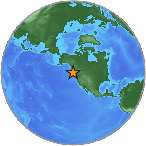
A swarm of very large earthquakes struck off the coast of Canada and Alaska, September 3, 2013 – USGS

A Canadian and Alaskan earthquake swarm on September 3, 2013 started with a 6.2 magnitude quake off the west coast of Canada.

The quakes took place on the Pacific Rim’s Ring of Fire, and very close to the dangerous Juan de Fuca plate off the northwest USA coast.

The Swarm

The first 6.2 quake was followed by several large quakes, and as I post this article, the quakes and tsunami warnings are still going on. These quakes began in Canada and moved into Alaska today:

  1. 6.2
  2. 4.6
  3. 4.8
  4. 5.5
  5. 5.0
  6. 5.9
  7. 4.2
  8. 5.9
  9. 5.8
  10. 6.5
  11. 5.4

And the night is not over yet …

Japan And Volcanoes

A picture of the Earth and the Ring of Fire with rising magma along the tectonic plates and cracks near Papua New Guinea.

The Ring of Fire along the Pacific Rim is lighting up.

Several hours after the Canadian quakes began, Izu, Japan had a 6.5 magnitude quake, also along the Ring of Fire. The Pacific Rim is shifting big time.

Watch for an increase in volcanic eruptions to happen next in these areas. And remember that more volcanic ash and debris that enters our atmosphere means that we may have a colder winter.

Heads up.


6.1 Quake At Vanuatu Kicks Off Quakes Along US West Coast

A USGS small globe showing the May 1, 2013 earthquake swarm around Vanuatu.

The west coast of the US is reacting to a 6.1 quake at Vanuatu, July 26, 2013 – USGS

A 6.1 magnitude quake at Vanuatu kicked off large quakes along the Western US coast, July 26, 2013.

Vancouver, Canada

The USGS small globe showing the July 26, 2013 5.1 earthquake.

Just hours after the 6.1 quake at Vanuatu, a 5.1 quake struck the Vancouver Island Region, Canada – USGS

Three hours after the Vanuatu quake, the Vancouver Island Region had a 5.1 magnitude quake 185 km (115 mi) west of Port Hardy.

 Vanuatu

I always watch the quakes at Vanuatu because the pattern that I have recorded shows strong quakes occur worldwide after Vanuatu opens up.

Here we go again …

The USGS small globe showing the earthquake at the South Sandwich Islands

A 6.2 magnitude quake happened on the South Sandwich Islands merely hours after a 6.1 quake rocked Vanuatu – USGS

South Sandwich Islands

Earthquake activity moved east into the South Atlantic near the South Pole when a 6.2 magnitude quake shook the South Sandwich Islands.

Over 188 earthquakes have occurred today, but in between these 6-pointers, the following larger quakes occurred:

  1. 6.2 South Sandwich Islands
  2. 5.1  South of the Fiji Islands
  3. 4.6 Koutouba, China
  4. 4.5 Adak, Alaska
  5. 4.9 Sikabaluan, Indonesia
  6. 4.6 Hirara, Japan
  7. 5.1  Port Hardy, Canada (Vancouver Island Region)
  8. 4.7 Tobelo, Indonesia
  9. 5.1  Petropavlovsk-Kamchatskiy, Russia
  10. 4.9 Katubao, Philippines
  11. 6.1 Luganville, Vanuatu

Lots of moving’ and shakin’ going on …

North And South Poles Continue to Shake With Increased Earthquake Activity

A USGS map of the Earth at the South Pole near Antarctica.

South Pole uptick in earthquake activity – USGS

The number of earthquakes at the poles is increasing, and over the past 72 hours, numerous large quakes have occurred at both the North and South Polar tectonic plates.

The Earth’s Crust Cracks Like An Egg

A picture of the shell cracked on a boiled egg.

The Earth’s crust cracks like the shell of a boiled egg.

When you boil an egg, the inner egg gets hot, and the harder outer shell cracks to release pressure. The Earth’s crust can be viewed in a similar way, albeit, the Earth is much more complex than an egg. But, the principle is the same.

The Earth’s “plate boundaries” are cracks in the “planetary egg”, and when the Earth heats up and shifts at the poles, the planet “vibrates” and the crust moves. Both the North and South Poles balance and spin in the middle of massive cracked plates.

Most of the plate boundaries cannot be seen because the Earth is far too big to see what’s hidden beneath the oceans. Yet, we know when the Earth moves because earthquake and volcanic activity increase near these polar boundaries.

In 1955, Einstein said:

When the mantle moves, the poles follow.

EQs Over The Past 72 Hours

In order of occurrence:

Northern Polar Region

  1. 4.3  Ft. McPherson, Canada
  2. 3.6  Ft. McPherson, Canada
  3. 5.3  Kuril’sk, Russia
  4. 4.3  Semisopochnol, Is, Alaska
  5. 4.7  Petropavilovsk-Kamchatskly, Russia
  6. 4.6  Petropavilovsk-Kamchatskly, Russia
  7. 4.3  Nikolski, Alaska
  8. 4.3  Homer, Alaska
  9. 4.4  Shawville, Canada
  10. 3.6  Shawville, Canada
  11. 3.5  Chirikof Is, Alaska
  12. 4.4  Petropavilovsk-Kamchatskly, Russia
  13. 3.5  Homer, Alaska
  14. 4.4  Petropavilovsk-Kamchatskly, Russia

Southern Polar Region

  1. 4.9  Raoul Is, New Zealand
  2. 5.3  South of Africa
  3. 5.0  South of Africa
  4. 5.0  South of Africa
  5. 5.7  South Mid-Atlantic Ridge
  6. 5.3  Visokol Is, South Atlantic Ocean
  7. 5.0  West Chile Rise
  8. 4.2  Rolleston, New Zealand
  9. 4.8  Southern East Pacific Rise
  10. 5.7  South of Africa
  11. 4.9  West Chile Rise

With this much activity at the polar plates, there is little doubt the poles are moving.