Hurricane Barbara Floods Mexico

The NOAA map of Hurricane Barbara

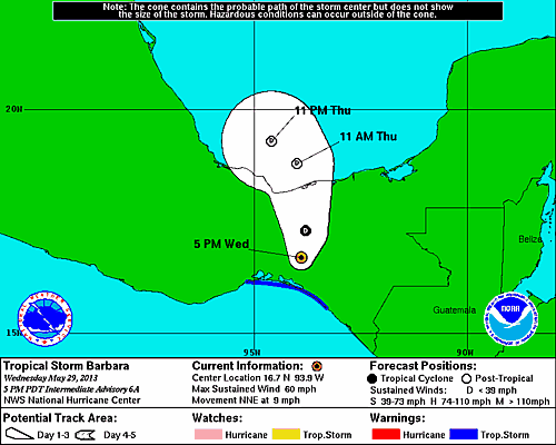
Hurricane Barbara hits Central America, May 29, 2013 – NOAA (click to enlarge)

Following Tropical Storm Alvin, Hurricane Barbara, the second storm of the eastern Pacific hurricane season, crashed ashore along Mexico’s southern Pacific coast, Wednesday May 29, 2013. A hurricane warning is in effect for Puerto Angel to Barra De Tonala Mexico, and a tropical storm warning is in effect for Barra De Tonala to Boca De Pijijiapan Mexico.

Barbara is expected to dump between 6-10 inches of rain over eastern Oaxaca and western Chiapas, with up to 20 inches possible in southeastern Oaxaca causing flash floods and mudslides.

A picture of a deadly landslide in Ecuador on january 24, 2013.

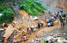
Deadly landslide in Ecuador on January 24, 2013.

During the last seven days, a significant increase in rainfall was received throughout Central America, Costa Rica, Panama, and parts of Guatemala.
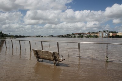
Global Flooding

Floods are blanketing the globe, actually, and the following countries/states are under current flood warnings:

Hawaiian Islands

Central America

England

Germany

Norway

Middle Mississippi River Valley

Malaysia

Alaska

Bahamas

North Dakota

Texas


Floods Covering Many US States

A picture of a river flooding a road.

Many US states are under massive river flooding.

Last weekend’s Spring winter-cold-snap has left many US states under water.

On May 6, 2013, flood alerts went out for the following states:

  1. North Carolina
  2. Arkansas
  3. Mississippi
  4. North Dakota
  5. Middle Mississippi Valley

Down On The Mississippi

The Mississippi River is currently flooding about 8,500 acres of farmland in East Carroll Parish’s Bunches Bend, Louisiana, which had a huge levee failure in 2011 that wiped out $10 million in crops. The 2011 breach on the levee’s northern end was fixed, but a gap remains on the southern end where the rising river is now depositing water. When the river reaches 42 feet, everything will be under water. The river is forecast to crest at 43 feet at Vicksburg, Mississipi by May 15.

Rains In California

Rain showers moved across Southern California on Monday, May 6, 2013, bringing much-needed moisture to help douse the remnants of a wildfire that blackened a 44-square-mile burn area in the western Santa Monica Mountains over the weekend.  The showers, heavy at times, marked a complete reversal of conditions that rapidly spread the blaze after it erupted early Thursday near the communities of Camarillo Springs and Thousand Oaks.

The fire threatened 4,000 homes, but only damaged 15 houses as it swept into Point Mugu State Park, where more than 85 percent of the 22-square-mile park burned.

And they say “it never rains in southern California.” Thank goodness it rained today.