Earthquake Under Kilauea Volcano Shakes Hawaii

A USGS map of the earthquake under Kilauea Volcano.

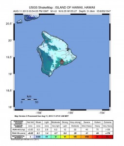
A 4.9 earthquake strikes beneath Kilauea Volcano, August 11, 2013 – USGS

A 4.9 magnitude earthquake shook the island of Hawaii, 5 miles south of the summit of Kilauea Volcano and at a depth of about 20 miles under the island. Tsunami watches went out, but no tsunami was generated – luckily.

Many “Big Island” residents felt the shaking and people as far away as Oahu and Maui reported feeling the earthquake. Over 400 reports were received within the first hour of the earthquake.

The 5.9 quake was followed minutes later by a 3.4 quake and a 2.9 quake as the activity settled down and the region reached equilibrium.
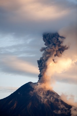
A Volcano-Quake

An underwater volcano smoking ash.

Underwater volcanic earthquakes should be taken seriously – especially for the residents on the island.

Wes Thelen, Hawaii’s Seismic Network Manager, said that these earthquakes were most likely structural adjustment of the Earth’s crust due to the weight of the island on the underlying mantle.

I disagree, and wonder why he doesn’t take this deeper (sorry about the pun). The Pacific Rim is more active today than it has been in recorded history, with an increase in both large earthquakes and volcanic activity.

The Earth’s oceans are warming, the crust is heating up, and the planet is shifting – big time. 

This 4.9 magnitude quake under the Kilauea Volcano signals that the magma deep beneath Kilauea is moving upward. For this much movement to occur, a shift in the mantle has taken place, yes, but this is not due to the weight of the “island” – it is due to the movement of hot magma coming closer to the Earth’s surface under Kilauea.

THIS was a volcano-quake.

Take It In Stride

Sometimes I wonder if earthquake magnitudes are kept just under the mark to make the increase in magnitudes seem lower – like 4.9 amd 5.9 as opposed to 5.0 and 6.0. This sounds less threatening, right? It serves little purpose to keep the people living near an active volcano in the dark. Have you ever watched the movie Dante’s Peak?

Watch it!

Be prepared, and stay aware. Enjoy the Hawaiian paradise, but also know that things are heating up under your feet!

Volcanic Eruptions Increase Worldwide

The following are volcanic eruptions that occurred Tuesday, May 7, 2013. Keep in mind that the CO2 emissions from each of these volcanoes averages about 950 tonnes per day – this is Nature’s own “global warming.”  Each of these volcanoes should be off limits to visitors, campers, hikers, and climbers around the summit craters.

A picture of Mount Mayon Volcano in the province of Bicol, Philippines.

Mayon Volcano in South Luzon, Philippines

Mayon – Luzon, Philippines

A powerful eruption from the summit crater of Mayon volcano in the Philippines occurred early morning, and killed 5 climbers and wounded at least 15 other people. They were surprised by an explosion that suddenly showered their camp with ballistic fireballs.

Reventador – Ecuador

The lava domes are active, with an occasional explosion and the emplacement of a hot avalanche or lava flow on the eastern flank where a new hot spot on the latest MODIS satellite data can be seen .

A picture of Tungurahua Volcano In Ecuador

Tungurahua Volcano In Ecuador

Tungurahua – Ecuador

An increase in eruptive activity is evident by continuous ash and steam emissions that are interrupted by cannon-like explosions producing ash plumes.  At night, explosive activity can be seen from the summit.  A significant SO2 plume can be seen on satellite data drifting to the NW.

Bagana – Bougainville Island, Papua New Guinea

Eruptions have intensified at the volcano. Over the past 2 days, several explosions have produced ash plumes rising to about 7,000 ft (2.1 km).

Batu Tara – Sunda Islands, Indonesia

An explosion produced an ash plume rising to 7,000 ft (2.1 km) altitude.

Paluweh – off shore Flores Islands, Indonesia

The Paluweh lava dome is relatively active, and is producing frequent explosions and hot rock avalanches. Hot deposits can be seen on MODIS satellite data on the eastern, southern and western flank of the dome. Several ash plumes rising to altitudes of about 7,000 ft (2.1 km) have been detected over the past few days.

Lukon-Empung – North Sulawesi, Indonesia

An explosion occurred at the Tompaluan crater that was heard up to 4 miles (6 km) away. Incandescent bombs were ejected approximately 650 feet  (200 m) from the crater. The eruption followed an increase in seismic activity starting Saturday, May 4.

Papandayan – West Java

Increased seismic activity has been detected at the volcano and the alert level has been raised to 3 out of 4. Sudden explosions can occur with little warning, and there is  a significant hazard to visitors around the volcano.

Cleveland – Aleutians Islands, Alaska

A large explosion occurred on Saturday, May 4, and continuous small eruptions are producing steam and ash plumes. The activity of the volcano is not monitored on ground, but is monitored by satellite data, which continues to show highly elevated surface temperatures at the summit.

Popocatepetl – Central Mexico

Emissions of steam and gas, with minor ash contents, have been venting around 1 per hour during the previous days, but continuing lava glow can be seen flowing from the summit. 

Santa Maria/Santiaguito – Guatemala

The lava dome is spewing sporadic, weak explosions, with minor activity from the lava flows on the flanks of the Caliente dome.

Pacaya – Guatemala

Weak explosive activity is continuous. It cannot always be observed, but can be heard and shows on seismic recordings.

Fuego – Guatemala

Six explosions produced gray ash plumes rising as high as 1,600 feet (500 m) above the crater.

Nevado del Ruiz – Colombia

A seismic swarm, indicating a rise of magma, resurged at the volcano. The largest quake was a magnitude 2.9, 3.5 miles ( 5.4 km) beneath the Arenas crater. It was felt around the volcano.

Two Earthquakes Shake Atlantic Ocean

The USGS small globe showing the 5.9 Earthquake off the Azores Islands, Portugal on April 30, 2013.

5.9 earthquake off the Azores Islands, Portugal on April 30, 2013 – USGS

Tuesday morning on April 30, 2013, two earthquakes just 30 minutes apart shook the Atlantic. The quakes were on opposite sides of the ocean, and surprisingly, neither rumbler created tsunami waves. The Azores Island 5.9 magnitude quake occurred 18 miles off the coast of Portugal 6.2 miles under the sea. (I consider this a 6.0 quake, but similar to gasoline prices advertised at $3.99 a gallon as opposed to $4.00 a gallon, many public posts try to make people think that “things” are not as bad as they could be.)

The USGS small globe showing the Caribbean earthquake April 30, 2013.

5.3 earthquake in the Caribbean Sea on April 30, 2013 – USGS

Thirty-one minutes later and 31 miles offshore Saint John’s, Antigua and Barbuda, a 5.3 quake rocked the Caribbean Sea 31 miles below the water.

Keep An Eye On Iceland

It would be unusual if the weaker parts of the Atlantic Ocean around Iceland and the Mid-Atlantic Ridge did not respond to these two Atlantic quakes occurring just 31 minutes apart on opposite sides of this vast ocean. Over the next week, keep an eye on the volcanoes around Iceland and on the volcanic Canary Islands, south of the Azores. And, monitor the Caribbean for more earthquake swarms.

As if upcoming hurricane season in the Atlantic isn’t enough to keep islanders on their toes, now they are experiencing large rumblers….