Eruption In Progress At Kamchatkan Volcano Making The Winter Cold Much Worse

Kamchatkan eruption from space - NASA

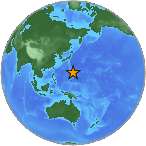
Kamchatkan eruption from space – NASA

A relatively large explosive eruption started January 21, 2014 and is currently in progress at Kamchatkan Shiveluch volcano, Russia. But this isn’t anything new.

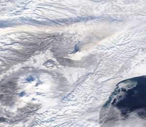
This ash plume rose to estimated 4.5 – 5 km (14, 760-16, 400 ft) altitude and is drifting west. The ash is thickening the atmosphere, and is exacerbating the heavy winter cold air and blizzard conditions impacting the Northern Hemisphere.

The volcano continues to produce intense degassing and ash venting. Glow from the active lava dome is visible on night-time webcam images.

When this much ash remains in the atmosphere and is circulated in the wind currents, you will have a drop in temperature and cooling.

Activation code is now orange.

Here is a slide show of the eruptions at Kamchatkan in January 2014 and December 2013 from NASA Terra/MODIS images and images from the Institute of Volcanology and Seismology FEB RAS, KVERT

This slideshow requires JavaScript.

Oh My – Yellowstone Is Bigger Than We Thought

A drawing of Yellowstone's supervolcano.

It comes as no surprise that larger amounts of magma are under Yellowstone.

The hot molten rock beneath Yellowstone National Park is 2½ times larger than previously estimated, but this comes as NO surprise.

Because we are small, humans have always seen everything else on the Earth as small. Until technology, that is. Now we are getting our proportions straight.

This planet is far bigger and much more powerful than humans will ever hope to be. Never mess with Mother Nature …

Supervolcano

There is more to our planet than meets the eye … like a supervolcano under Yellowstone that has the potential to erupt with a force about 2,000 times the size of the largest eruption at Mount St. Helens.

Something pretty darn deep has been regulating Old Faithful all these centuries, don’t you think? Now, we know “what.”

By measuring seismic waves from past earthquakes, scientists at the University of Utah have mapped the magma chamber underneath the Yellowstone caldera. The chamber is 88.5 km long (54 miles), 29 km wide (18 miles), and is 5 km to 14.5 km ( 3 miles to 9 miles) deep below the Earth’s surface.

This means there is enough volcanic material below the surface to match the largest of the supervolcano’s three eruptions over the past 2.1 million years.

This is amazing, but oh my, this is also very dangerous.

Yellowstone’s Climate Change

The largest blast ever at Yellowstone was 2,000 times the size of the 1980 eruption of Mount St. Helens in Washington State. A similar eruption would spew large amounts of volcanic material into the atmosphere, where it would circle the Earth and result in some serious climate changes. There would be a lot of destruction and a lot of deadly impacts around the globe.

The last Yellowstone eruption happened around 640,000 years ago, according to the geologic record. For years, observers tracking earthquake swarms under Yellowstone have warned that the caldera is overdue to erupt, yet we are incapable of predicting when the next eruption will be.

Advanced Warnings

There are enough instruments monitoring the seismic activity under Yellowstone that scientists will likely know well ahead of time if there is unusual activity happening or magma is rising to the surface.

Many large volcanos, like Yellowstone, are located all over the Earth. Actually, magma chambers fill most of the subsurface under the crust.  We are just now awakening to this fact, but it’s better late than never to understand this, don’t you think?

Earthquake Swarms At Canary Islands, Puerto Rico, and Mariana Islands

Large earthquakes get our attention for many reasons, but sometimes, the earthquake swarms can be more dangerous than the big quakes.

Earthquake swarms are a sign of major earth movement, and they also warn of underlying volcanic activity. Either way, earthquake swarms are a warning to pay attention before major damage is done.

Right now, there are three areas of significance that are experiencing earthquake swarms :

  1. Canary Islands; approx 120 quakes above 1.8 magnitude and more than 40 quakes up to 3.2 magnitude in the past 24 hours
  2. Puerto Rico; occurring at same time the US Craton quakes occurred
  3. Mariana Islands; on the volatile Ring of Fire and SW of the Mariana Trench/subduction zone.
Small USGS globe of Puerto Rico in the Caribbean Sea

Earthquake swarm at Puerto Rico in the Caribbean Sea – USGS

The USGS small globe showing the 5.9 Earthquake off the Azores Islands, Portugal on April 30, 2013.

Earthquake swarm at the Canary Islands in the Atlantic – USGS

USGS small globe of Mariana Islands

Earthquake swarm north of the Pacific Mariana Islands – USGS