6.8 Magnitude Earthquake Strikes Papua New Guinea 12 Hours After 7.8 Quake Hits Iran

The USGS small globe showing the location of the 6.8 earthquake that struck Papua New Guinea on April 16, 2013

6.8 earthquake strikes Papua New Guinea April 16, 2013 – USGS

A 6.8 magnitude earthquake struck Papua New Guinea merely 12 hours after a 7.8 quake hit Iran, and there were 26 earthquakes that occurred globally in between the two quakes.

Don’t forget that on April 6, 2012, merely 10 days earlier, a magnitude 7.0 earthquake struck the center of Papua, Indonesia, which is the mountainous portion of the island, west of Papua New Guinea.

No Tsunami Warning

No destructive widespread tsunami threat occurred, however, earthquakes this size sometime generate local tsunamis that can be destructive along the coasts located within a hundred kilometers (50 miles) of the earthquake epicenter. The region has been alerted to be aware of this tsunami possibility, and to take appropriate action.

The USGS map of Papua Indonesia witha star where the 7.0 magnitude earthquake struck 4-6-13

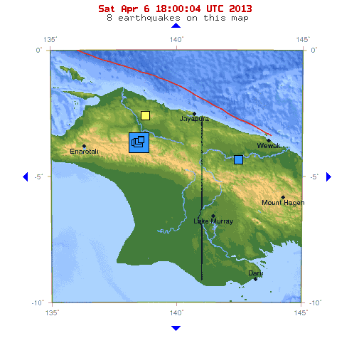
7.0 magnitude earthquake that hit Papua Region, Indonesia on April 6, 2013 – USGS

A USGS map of the island of NEw Guinea and the location of the April 16, 2013 6.8 earthquake

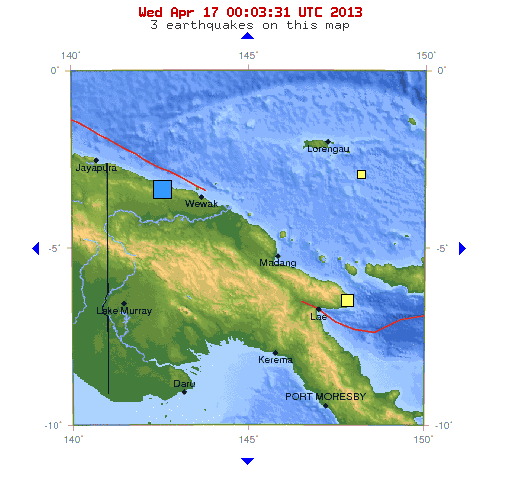
6.8 magnitude earthquake that struck Papua, New Guinea on April 16, 2013 – USGS

Subscribe to Blog via Email

Enter your email address to subscribe to this blog and receive notifications of new posts by email.

About Janet

Janet Starr Hull, PhD, CN has expressed a deep love and respect for the Earth since she was a very young child. She earned academic degrees in International Geography and Environmental Science. After 20 years of research, Dr. Hull uncovered evidence supporting her theory that the Earth’s geographic poles shift at the axis, causing dramatic climate change. Today, she is one of the world’s leading environmental experts promoting public environmental awareness. Connect with Dr. Hull on Facebook, Twitter, and Google Plus.

Comment With Facebook: