Earthquake In Pakistan Creates New Island

The small island off Pakistan.

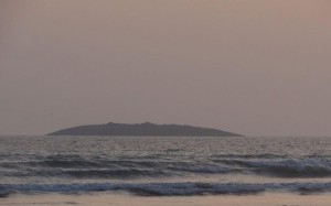
A small island rose out of the Arabian Sea after a 7.8 earthquake in Pakistan – Photo off Twitter: @Senator_Baloch

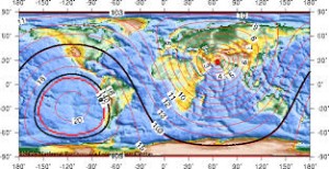
On Tuesday, September 24, 2013, a series of large earthquakes hit Awaran, Pakistan northeast of the Persian Gulf and the Gulf of Oman.

The largest quake was 7.8 in magnitude (now downgraded to a 7.7 magnitude), and local reports from the region initially estimated at least 150 people were buried beneath the rubble.

Chaotic Region

Earthquake activity and faulting around this region are very chaotic because many different forms of crustal faulting take place in this one area:

The Himalayan Mountains.

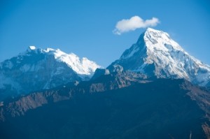
The Himalaya Mountains have been pushed up north of India due to compression.

  • subduction (one plate goes under another)
  • large-scale transform faulting (plates slip and slide past one another)
  • compression (mountain building and crustal extension)

The Earth’s crust is very thick here due to compression, which forms the Himalaya Mountains. Because of the three different types of crustal movement in and around this part of the world, many earthquakes occur in this region. As the Earth’s axis continues to wobble and shift, we may see future earthquakes increase in magnitude north of the Middle East and within the Indian Ocean.

Head’s up.

Rising From The Sea

No one expected, however, to see a new island rising from the sea – and instantly! This sounds like something from the Dreamworks studios.

Local news crews filmed the rocky uplift rising out of the Arabian Sea while a crowd of bewildered people (still shaking from the earthquake) gathered on shore to witness this rare phenomenon.

Wouldn’t you love to have seen this ?

The earthquake was so powerful, it opened a chasm that pushed the seabed up. This created a small, mountain-like 60′ island to rise out of the Arabian Sea about 600 meters (656 yards) visible off Pakistan’s coastline.

Mystery Island

Over time, this new island may continue to grow in size – or it may wash itself out and sink back beneath the ocean – time will tell. This is how many of the islands that we “see” today formed in the Earth’s past.

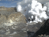
Scientists are arguing about its origin and importance, with some saying that this is simply “mud rising” from a mud volcano, and is no big deal. Mud volcanoes are a temporary formation formed by a jet of mud, sand, and water that gushes to the surface after a large earthquake occurs under the ocean floor.

I think that this is a very big deal because it isn’t a normal occurrence. It is commonly known that volcanic activity occurs at subduction zones, and there is subduction in this area. As the Earth’s interior continues to heat and expand, this can be a magma rise.

In The Past

Islands in this area have risen from the Arabian Sea in the past. Back in the 1940s, another island rose from the sea in the area, but it didn’t remain above water for long. After an earthquake near Karachi struck, the British Indian Geological survey recorded a new island big enough for people to land a boat and walk on, but over time, it either washed away or the sea level rose enough to cover it in water.

One big factor that is going unnoticed right now is that this area is repeating geologic events of large earthquakes and the appearance of island land masses. Here it comes again.

To me, THIS is an Earth event that is most fascinating, and a phenomena worth following in the future. It may be much more significant than scientists think.

How cool is this?


A Resurge In Big Earthquakes Today

A USGS map of the Middle East and Pakistan.

Pakistan is having a swarm of large earthquakes north of the Persian Gulf – USGS.

I woke up this morning to my PDC Disasters Alert app going off non-stop. It’s been rather quiet for a few days, and this was  a calm before the storm, it appears.

Today, there has been a resurge in some big quakes.

Early Quakes On Tuesday, September 24, 2013

In order of occurrence:

  1. 5.6  Carlsberg Ridge (west of Persian Gulf)
  2. 7.8  Awaran, Pakistan (approximately 150 killed, north of Persian Gulf)
  3. 5.9  Awaran, Pakistan
  4. 4.7  Awaran, Pakistan
  5. 5.0  Awaran, Pakistan
  6. 5.7  Awaran, Pakistan
  7. 5.6  Awaran, Pakistan
  8. 4.8  Hachijo-shima, Japan
  9. 5.1  Chichi-shima, Japan
  10. 5.2  Khuzdar, Pakistan
  11. 4.8  La Ligua, Chile
  12. 4.9  Awaran, Pakistan
  13. 5.0  Druzhina, Russia
  14. 5.5  Aaran, Pakistan

State-Side

Map of Typooh Pabuk heading toward Japan.

Typhoon Pabuk heads toward Japan – AcuWeather.com.

Now, throw in a few quakes around Yellowstone and the Western US today:

  1. 3.2 West Yellowstone, Montana
  2. 3.0 Smith Valley, Nevada
  3. 3.0 Leavenworth, Washington

And then, throw in Typhoon Pabuk heading toward Southern Japan (just to stir things up a bit …)

It’s been an active morning. Let’s see what the afternoon brings.


Large Alaska Quakes Are At It Again

A map of Alaska

Atka, Alaska is on the Alaskan Aleutian Island Chain located on the Pacific Ring of Fire.

If you want some excitement in your life, go to the hamlet of Atka, Alaska. So far this month, Atka has had several powerful earthquakes, and the small community has a volcano just outside its city limits.

Who needs cable television?

Last week, Alaska and Canada both had a round of powerful earthquakes, and the volcanoes along the Aleutian Islands in Alaska are building up pressure.

Atka Earthquakes

Today, Saturday September 14, 2013, Atka is at it again – there have been 5 earthquakes (so far) over 5.0 magnitude that occurred within an hour.

Merely 10 days before, on Wednesday September 4, 2013, a 6.5 magnitude quake struck in the same location southwest of Atka.

The following quakes occurred on Saturday southwest of Atka, all within an hour:

  1. 5.0
  2. 5.4
  3. 5.8
  4. 5.3
  5. 5.2

Atka Volcanoes

Atka volcano is the largest volcanic center in the central Aleutians, and is surrounded by 8 satellitic volcanoes.

Korovin volcano is the highest point on Atka Island along the Aleutian Islands chain. Korovin is a side vent to the main Atka shield volcano, and is the highest point on the island.

Korovin last erupted in 2006, but with earthquake activity increasiing around Atka today, I’d expect some volcanic activity to follow.

Alaska Volcanoes

A picture of the White Island volcano

Volcanic eruptions are increasing along the Alaskan Peninsula.

Two of Alaska’s most active volcanoes—Pavlof and Cleveland—are currently erupting.

Located close to the western end of the Alaska Peninsula, Pavlof is one of the most active volcanoes in the Aleutian arc, having erupted more than 40 times since the late 1700’s. Pavlof has been erupting since May 13, 2013.

Keep a watchful eye on our 49th State. Alaska is rockin’ and rollin’ and heatin’ up these days.