Small Tsunami Hits US East Coast

A picture of a large ocean wave.

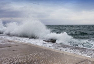
A small tsunami hit the US East Coast June 13, 2013

Few people noticed that on June 13, 2013,  a small tsunami hit the East Coast of the US from Massachusetts to North Carolina to the Caribbean.

NOAA used 30 different tide-measuring gauges to pick up the tsunami tides that were 1 to 6 feet above normal along the coast – plus, they wanted to confirm that this was really happening.

Tsunami Or Storm Surge?

When you see a sudden 6 foot wave sweeping people off the beach, you know you have a problem. A tsunami is any unexpected series of destructive and fast-moving waves coming on shore, and this is what happened June 13.

NOAA doesn’t know for sure if the tsunami was caused by a shift in the continental crust at the bottom of the Atlantic Ocean, or if it was caused by a storm surge, even though no major storms occurred in the Atlantic at the time. They are definitely researching to see if the sea floor shifted in the Atlantic.

Earthquakes And Super Moon

Something else no one is paying much attention to is the fact that the Atlantic Ocean IS experiencing an increase in earthquakes, and a few days after this small tsunami, a 6.6 magnitude quake hit on the Mid-Atlantic Ridge (later downgraded to a 6.4 magnitude). So, the bottom of the Atlantic is active and it is shifting.

And don’t forget that the Super Moon is still influencing the Earth, but it peaked the same week as the tsunami and the Atlantic 6.6 quake. Three more large quakes occurred at the equator during this once-a-year full-moon event, with the largest quake in the Atlantic Ocean.

Increase In Global EQS And Tsunamis

The USGS small globe showing the 5.9 Earthquake off the Azores Islands, Portugal on April 30, 2013.

Earthquakes in the Atlantic Ocean can send tsunami waves onto the east coast of the US and into the Caribbean.

Any and all coastlines are susceptible to tsunami waves, and as the Earth’s axis continues to sway and vibrate, don’t be surprised to hear of more tsunamis occurring.

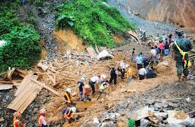
Tsunamis are normally generated by offshore earthquakes, sub-marine landslides, and undersea volcanic activity. One of the largest tsunami threats to America’s east coast is likely to begin on the Canary Islands off the coast of North Africa.

Both volcanoes and sub-marine landslides are occurring here, and this can cause a wall of water to race across the Atlantic Ocean at the speed of a jet airliner, which can devastate the east coast and the Caribbean.

My guess is more small tsunamis will be hitting the US in the days to come because as the Atlantic sea floor moves, shakes, and uplifts, the water has to go somewhere. 


Hurricane Barbara Floods Mexico

The NOAA map of Hurricane Barbara

Hurricane Barbara hits Central America, May 29, 2013 – NOAA (click to enlarge)

Following Tropical Storm Alvin, Hurricane Barbara, the second storm of the eastern Pacific hurricane season, crashed ashore along Mexico’s southern Pacific coast, Wednesday May 29, 2013. A hurricane warning is in effect for Puerto Angel to Barra De Tonala Mexico, and a tropical storm warning is in effect for Barra De Tonala to Boca De Pijijiapan Mexico.

Barbara is expected to dump between 6-10 inches of rain over eastern Oaxaca and western Chiapas, with up to 20 inches possible in southeastern Oaxaca causing flash floods and mudslides.

A picture of a deadly landslide in Ecuador on january 24, 2013.

Deadly landslide in Ecuador on January 24, 2013.

During the last seven days, a significant increase in rainfall was received throughout Central America, Costa Rica, Panama, and parts of Guatemala.

Global Flooding

Floods are blanketing the globe, actually, and the following countries/states are under current flood warnings:

Hawaiian Islands

Central America

England

Germany

Norway

Middle Mississippi River Valley

Malaysia

Alaska

Bahamas

North Dakota

Texas


From Earthquakes To Severe Storms To Floods In Oklahoma

A weather map of severe storms over Oklahoma, Texas, and Arkansas on April 18, 2013

Severe Storm Outbreak April 18, 2103 – AccuWeather.com

After 16 earthquakes rattled Oklahoma over the past two days, now the Sooner State is under a severe storm and flood alert.

Severe Storms

A major outbreak of severe thunderstorms is expected to hit across the central and southern Plains on Wednesday, April 18, 2013. This outbreak has the potential to be one of the worst of the year.

Cities with the greatest potential for severe weather include Dallas, Wichita Falls, and Abilene, Texas, Oklahoma City and Tulsa, Okla., Chanute, Kan., and Joplin and Springfield, Mo.

Flood Alert

Even before these storms hit on Wednesday, Southeastern Kansas and Northeastern Oklahoma are already under a significant flood alert, with river flooding likely over the next five days. In general, flooding is likely to effect roads, residential, commercial, industrial, and agricultural areas, and may require evacuation of people and/or livestock.

Heads up, Oklahoma. Spring storms are heading your way.