14,000 Hiroshima Bombs Pointed At The Pacific

A black and white radioactive sign.

The radiation threat at Fukushima in November will be at catastrophic levels.

This is what is happening at Japan’s Fukushima nuclear reactor in November. The fuel removal from Reactor 4 will match the fallout of 14,000 Hiroshima bombs if something goes wrong.

I am not a gloom-and-doomer, but I am a realist, and the chances are high that the removal of over 1300 spent fuel rods from a malfunctioning fuel storage tank could go wrong.

These fuel rods hold enough radiation  to equal 14,000 nuclear bombs. If another accident occurs, radiation will spill into the Pacific Ocean, evaporate into the atmosphere, and will circulate all over the Northern Hemisphere – for decades.

The bring-down of the fuel rods from Fukushima Reactor 4 is the most dangerous engineering task ever undertaken in human history.

Two Weeks From Now

The damaged Fukushima nuclear reactor.

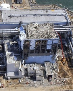
Reactor 4 at the Fukushima nuclear reactor is tipping and sinking into the ground.

As early as November 8, 2013 – the operation is due to begin. Reactor 4 is tipping and sinking, and will not withstand another large earthquake or tsunami like the 9.0 magnitude quake and tsunami that destroyed the nuclear power plant in 2011.

This operation is dangerous enough on its own, but what happens if another earthquake occurs, followed by a tsunami of any size, or if a typhoon smacks into the Japanese coastline?

Recent Earthquakes

On Friday, October 25, 2013, a 7.5 magnitude earthquake occurred about 200 miles east of Honshu, Japan, the location of the Fukushima nuclear reactor. A small tsunami watch was issued, but waves merely rose about 3 feet. The 7.5 quake was downgraded to a 7.1.

After the 7.5 magnitude quake (7.1 really??), this area has experienced the following earthquakes:

  1. 5.1  Honshu 10/25/13
  2. 4.8  Honshu 10/25/13
  3. 5.5  Honshu 10/25/13
  4. 4.9  Honshu 10/25/13
  5. 4.6  Honshu 10/25/13
  6. 4.7  Honshu 10/26/13
  7. 4.4  Ishinomaki, Japan 10/26/13 (about 40 mi from Fukushima)
  8. 5.5  Honshu 10/27/13
  9. 5.0  Honshu 10/27/13
A weather map of Typhoon Wipha.

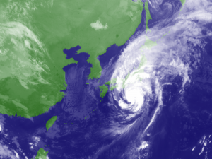
Deadly Typhoon Wipha was a once in a decade storm.

Typhoons

Typhoon Wipha hammered Japan in early October, followed by Typhoon Francisco that passed close to the island on Saturday.

It is expected to take over one year to remove the spent fuel rods from Reactor 4 – I suspect the threat of another typhoon will be knocking on Japan’s door sometime between now and then.

This human disaster could result in massive destruction for all life on our planet if another natural disaster occurs at Honshu.

Sadly, all any of us can do is just wait and see …


Deadly Typhoon Wipha Slams Japan

A weather map of Typhoon Wipha.

Deadly Typhoon Wipha is a once in a decade storm.

As if Japan needed another natural disaster, Typhoon Wipha just passed over the island of Izu Oshima, south of Tokyo, bringing strong winds and 80 cm (31 1/2 in) of rain in merely 24 hours.

Fourteen people have been killed in landslides, so far, and houses have been buried or completely destroyed, and many more are unaccounted for.

Now, watch Tokyo and Fukushima as Wipha tracks north.

Once In A Decade Storm

The Japan Meteorological Agency reported the storm as the most powerful in ten years, and the amount of rain has surpassed their records, which date back to 1991. 122 mm (5 in) of rain fell in just one hour on Wednesday morning.

After passing Izu Oshima, 20,000 people were ordered to evacuate as the typhoon approached Japan and the storm moved northward over the mainland of Japan.

Deadly Landslides

Due to landslides, rescue efforts are hampered on Izu Oshima. Affected areas are difficult to reach and search. Almost 300 homes have been destroyed on the island, and the full extent of the damage is still being assessed.

Updates from International Charter: Space and Major Disasters

Volcanoes Ramping Up Worldwide

The eruption of Santiaguito volcano

Eruption of Santiaguito volcano in Guatemala (webcam image: INSIVUMEH, annotated by Blog Culture Volcan)

Santiaguito Volcano – Guatemala

A major eruption occurred August 22, 2013. The top part of the Caliente lava dome collapsed and produced a series of relatively large pyroclastic flows and explosions. Ash plumes rose to elevations of 4 km (13,000 ft) in altitude.

The pyroclastic flows affected mainly the south, southeast and NNE sides of the volcano, but volcanic bombs from explosive activity were ejected up as far as 500 m (1,600 ft).

Fuego volcano – Guatemala

Fuego Volcano Guatemala

As seen at night, Fuego’s increasing lava is flowing toward Taniluya, Guatemala and Ceniza Canyon.

A surge of activity occurred overnight on August 19, 2013. Two active lava flows are heading towards Taniluya (on the western flank) and the Ceniza Canyon (on the southern flank). The lava flows have increased to 600 and 800 m (2,600 ft) in length, respectively.

Numerous incandescent avalanches are detaching from the lava flow fronts, and glowing blocks of rock are reaching past the vegetation limits.

Explosive activity from the summit crater has remained weak, with only few strombolian type explosions with incandescent bombs ejected up to 150 m (500 ft), and ash plumes rising up to 400 m (1,300 ft) in height.

Sakurajima Volcano

Strong explosions are occurring at Sakurajima Volcano – NASA

Sakurajima Volcano – Japan

On August 21, 2013, Sakurajima had at least eight explosions with ash plumes rising up to 4.5 km (15,000 ft) altitude that drifted over Kagoshima city causing ash fall. The volcano has been in an elevated state of activity during the past weeks. A significant hot spot suggests that magma levels are high in the crater, and significant amounts of  hot, fresh deposits are visible on the flanks of the volcano.

The next day on August 22, 2013, a very large explosion occurred (one of the largest this year). It produced a mushroom shaped ash column that rose about 6 km (20,000 ft) in altitude that drifted over Kagoshima.

Kizimen Volcano – Kamchatka, Russia

The lava dome continues to grow at the top of the volcano, and rockfalls and small pyroclastic flows can be seen glowing from the volcano. Ash plumes are intensifying at the volcano, and webcams have spotted a new prominent spine being extruded from the top of the cone.

Iliwerung Volcano – Lesser Sunda Islands, Indonesia

A submarine eruption occurred Thursday, August 23, 2013 in Indonesia. The alert level of Iliwerung volcano was raised from 1 (normal) to 2 (watch) following increased seismic and visual activity from an underwater flank vent called Gunung Hobal.

Iliwerung volcano forms a peninsula on the south coast of Lembata (Lomblen) Island, East Indonesia. Mount Hobal (Gunung Hobal) is a submarine flank vent of Iliwerung located about 800 m (2.600 ft) off the coast. Iliwerung has had several historic eruptions during which several temporary islands were formed.

White Island Volcano – New Zealand

A picture of the White Island volcano

Phreatic explosion at White Island, August 23, 2013 (GeoNet webcam)

A small phreatic or hydrothermal eruption occurred in the active crater, Tuesday August 20, 2013. The explosion lasted for about 10 minutes and produced a steam plume mixed with small amounts of ash that rose about 4 km (13,000 ft).

 Many More

There are many more volcanoes increasing in activity worldwide. The point to remember at this time is that the size of one eruption is not what changes our planet’s climate – it’s the number of volcanoes erupting at the same time.