The Earth Expansion Theory – Why Islands Rise From The Sea

A woman sweating.

When your body heats up, you sweat to naturally cool off.

What happens to your body when you exercise? Your body heat increases, right?

As body heat increases, it expands to escape through the pores of your skin. You sweat more as a natural cooling mechanism to keep your body temperature balanced.

Well, the Earth does the same thing – just on a mega-scale.

The Earth’s Core

The Earth's core.

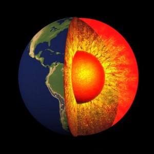
The Earth’s core is hot, very hot, and as the heat rises, it expands at the surface of the Earth.

Our planet is hot, very hot, deep inside. There are three main sources of heat within the Earth:

  1. heat from when the planet first formed, which is still in there;
  2. frictional heating, caused by the dense core material sinking toward the center of the Earth;
  3. heat from the decay of radioactive elements.

Just as heat inside of your body expands to escape through your pores, the heat inside of the Earth expands to escape through the cracks in the crust.

Here’s a glitch, though – like your skin, the outer crust acts like a blanket that traps the inner heat. When the Earth gets hotter, the excess heat must release, so it escapes through cracks in the crust causing earthquakes and volcanic eruptions.

Fracking and excessive oil and gas drilling weaken the crust, and this opens the door to more Earth expansion at the fractures, holes, and cracks in the crust.

A picture of the shell cracked on a boiled egg.

As heat rises from the core of the Earth, it escapes at the surface much like the inside of a boiling egg oozes out of cracks in the shell.

Earth Expansion

Now, what happens when you boil a pot of eggs? The heat of the pan increases the heat of the water, which heats and hardens the egg.

Well, the Earth does the same thing – just on a mega-scale.

As the Earth releases heat, the crust expands when the heat rises and escapes, much like the inside of a boiling egg oozes out of a crack in the eggshell.

The more heat – the more cracks.

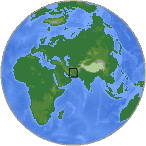
Pakistan Island Rising

The small island off Pakistan.

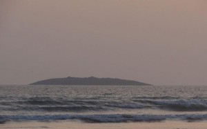
A small island rose out of the Arabian Sea after a 7.8 earthquake in Pakistan – Photo off Twitter: @Senator_Baloch

Following a swarm of large earthquakes in Pakistan on September 24, 2013, within hours an island rose out of the Arabian Sea.

Its appearance was caused by Earth expansion, and as the planet continues to release heat under the crust, more events like this are sure to happen all over the planet.

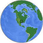
Check out the vimeo I did with Michael Edward on Earth expansion in the Gulf of Mexico after the BP oil spill in 2010. As you will see, there are lots of “cracks” in the Gulf – some are natural and many are man-made.

The Earth Expansion Theory is powerful information that explains crazy Earth movements like islands rising from the sea.

Hey, it’s not every day that you can watch an island form. I guess the Earth’s been working out lately.


7.8 Magnitude Earthquake Splits the Iran-Pakistan Border While Six Earthquakes Shake Oklahoma

A USGS small globe showing April 16, 2013 7.8 EQ in Iran

April 16, 2013 7.8 earthquake in Iran – USGS

After a recent earthquake swarm along the Persian Gulf in Iran, a second deadly earthquake in less than one week shook Iran close to the Iran-Pakistan border in Khash. The 7.8 magnitude quake on April 16, 2013 was the strongest earthquake to hit Iran in more than 50 years, killing at least 46 people in the sparsely populated area and swaying skyscrapers and buildings as far away as New Delhi, India. According to USAToday, Iran’s emergency crew, The Red Crescent, said it was facing a “complicated emergency situation” in the area with villages scattered over desolate hills and valleys.

Meanwhile on the other side of the planet, Oklahoma had six earthquakes within an eight mile radius, and Old Faithful Geyser, Yellowstone National Park, Wyoming rumbled from a second small quake to shake Wyoming over the past week.

Iran EQ Started in Oklahoma

The USGS small globe showing the April 16, 2013 earthquakes in Oklahoma

April 16, 2013 earthquakes in Oklahoma, USA – USGS

This earthquake activity actually started on the North American Plate in Oklahoma along the prehistoric Craton Plate boundary in the southern USA. The Craton boundary is the location of the North American continental shoreline over 65 million years old, and earthquakes along this ancient southern plate boundary are increasing in Oklahoma, Texas, Arkansas, and along the Gulf of Mexico and Mississippi River Valley.

Rockin’ In OK

The USGS map of the April 16, 2013 earthquakes in Oklahoma and the location of the ancient Craton Boundary in Oklahoma

USGS map of the April 16, 2013 earthquakes in Oklahoma showing the location of the ancient Craton Boundary in the southern USA/Oklahoma

At 1:45 AM CST, Chandler, Oklahoma split the night with a 3.0 magnitude earthquake, followed 13 minutes later by a 4.6 quake four miles away in Luther, Oklahoma. At 2:15 AM CST, Boley, Oklahoma rattled with a 2.9 magnitude quake, and a 3.3 quake 1 minute later snapped back to Luther. Three hours after that and to the minute at 5:16 AM CST, Luther, Oklahoma had another quake with the highest magnitude so far, registering 4.2.  At 12:06 PM CST, Luther had Oklahoma’s sixth eq of the day, registering 3.5 magnitude.

At 4:46 AM CST, a 3.0 quake rattled Old Faithful in Yellowstone National Park, on the western side of the Craton Boundary. One hour later on the other side of the world, the Earth split at the Iran-Pakistan border with a 7.8 magnitude quake.

Keep an eye on USGS because today has only started.