Volcanoes Sinking Into The Ocean

Earth question symbol represented by a world globe model with a geographic shape of a mark questioning the state of the environment the international economy and political situation.

Are volcanoes really sinking into the ocean?

Scientists aren’t sure if they discovered a fluke, or if volcanoes located on earthquake subduction zones are actually sinking.

The two major earthquakes in Chile (2010) and in Japan (2011) caused a number of big volcanoes to sink up to six inches, according to a new scientific discovery. These two events were the first to be detected by scientists because they just so happened to have the right instruments in orbit to capture this data. Otherwise, this phenomenon might have gone unnoticed.

Similar sinking might be happening after big quakes in Alaska, Indonesia and other major subduction zones where megaquakes typically occur.

Now we’ll know to look.

A picture of Chirinkotan volcano in the Kuril Islands, Eastern Russia

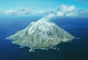
Megaquakes are causing volcanoes to sink into the sea.

Megaquakes

Megaquakes are earthquakes with magnitudes above 8.0. These quakes spawn tsunamis, crumble buildings, cause the loss of life, and open up the surface of the Earth.

Following the 8.8 magnitude Maule earthquake in Chile in 2010, and the 9.0 magnitude Tohoku earthquake in Japan in 2011, scientists analyzed satellite data to look for markers of increased volcanic activity. What they found was the volcanoes appeared to react to the earthquakes by sinking. The two teams of scientists who worked independently on researching volcanoes in Chile and Japan, recently published their respective papers in the online journal Nature Geoscience, June 30, 2013.

Increase in Large Earthquakes

There is no doubt that over the last 6 1/2 years after the 2004 megaquake in Sumatra, there have been more great earthquakes occurring around the world than in any 6 1/2-year period in the 110-year history of seismic recordings.

We’ll have to monitor these quakes more closely, and watch the volcanic responses to these quakes.

There is no doubt that we are learning as we go … Nature is full of surprises.


5.7 Quake In Greenville, California Starts Earthquake Swarm

A USGS map of the May 23, 2013 quake in Greenville, California

May 23, 2013 quake in Greenville, California (click to enlarge)

A 5.7 earthquake struck Greenville, California late Thursday night, May 23, 2013, but the quake didn’t stop there.

The Greenville area experienced 62 quakes following the 5.7 rumbler, with the largest quake a 4.9 magnitude.

The initial earthquake was felt in downtown Sacramento, about 145 miles south of the quake’s epicenter.

Juan de Fuca

The next day on May 25, 2013,  more earthquakes occurred off the coast of Oregon (4.0) and in Coldfoot, Alaska (4.4).

The Juan de Fuca Plate is one of the most active, and dangerous, crustal plates on our planet, and it is an area to carefully monitor for both upcoming earthquakes and volcanoes.

A USGS chart and map describing the Juan de Fuca tectonic plate.

The Juan de Fuca Plate off the USA Pacific Northwest – USGS (click to enlarge)

In the Pacific Northwest, the Juan de Fuca Plate plunges under North America. As the denser ocean crust is forced deep into the Earth’s interior beneath the continental plate at the USA’s West Coast (a process known as “subduction”), it encounters high temperatures and pressures that partially melt the rock. Some of this newly formed magma rises toward the Earth’s surface to erupt, forming a chain of volcanoes above the subduction zone.

Between the Pacific and Juan de Fuca Plates is a broad, submarine mountain chain about 500 kilometers long (300 miles) known as the Juan de Fuca Ridge.

The Juan de Fuca Plate will continue to dive beneath Oregon and  the High Cascades, so keep an eye on activity coming from the Juan de Fuca.