Brazil Confirms Amazon Deforestation On The Rise

A bird's eye picture of the Amazon River in Brazil.

The lush Amazon River and surrounding rainforest in Brazil.

Data recently released by the Brazilian government confirms an increase in Amazon forest loss.

Brazil’s National Space Research Institute, INPE, updated data from its near-real-time deforestation tracking system, known as DETER. The system showed a near five-fold increase in forest loss during the month of May 2013 relative to a year earlier in May 2012, from 99 square kilometers (24,463.4 acres) to 465 sq km (114,904 acres) lost.

DETER shows that annual deforestation is 14 percent higher from 2,051 sq km (506,813,137,389 acres) lost in 2012 to 2,329 sq km (575,508,433,437 acres) disappearing today.

This time last year, deforestation was the lowest since annual record-keeping began in the late 1980s.

Fifty-nine percent of the clearing occurred in Mato Grosso, a state in the Southern Amazon where large-scale farms and cattle ranching drive most deforestation. It would be interesting to uncover which foreign corporations are involved in this increased deforestation in Mata Grosso.

braz_defor_chart

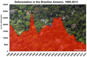
Chart showing the increase in deforestation in the Brazilian rainforest.

Deforestation On The Rise

INPE’s data was confirmed by Imazon, a Brazil-based NGO, which showed an 89 percent annual increase in deforestation from 2012 to 2013.

Between August 2011 and May 2012, INPE determined that 873 sq km (215,723 acres) of forests were lost to development, but between August 2012 and May 2013, 1,654 sq km (408,712,300,947 acres) were lost. Imazon uses the same data, but employs a different methodology for estimating change in forest cover.

Chart showing deforestation in the Brazilian Rainforest

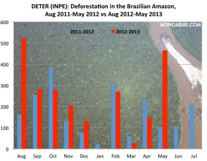
Chart showing the increase in deforestation in the Brazilian rainforest from 2011 to 2013.

Both near-real-time systems aren’t as accurate as the systems used for tracking annual deforestation, which is measured at the peak of the dry season each year when cloud cover is at a minimum. The shorter-term tools, which have relatively coarse resolution, are used mostly for alerting authorities on the location of forest clearing, rather than measuring changes in forest cover.

No matter what the figures say, deforestation has dramatically increased over the past year, and THAT purpose is to fulfill farming and cattle ranching for the benefit of countries outside of Brazil

Original post from Dylan Charles/Waking Times

Prehistoric Continents Discovered Off India And Brazil

icutre of Indian Ocean Vintage Map

Indian Ocean Vintage Map

On March 3, 2013, researchers found evidence of a landmass estimated to have existed between 2,000 and 85 million years ago.  The fragments of an ancient continent are buried beneath the floor of the Indian Ocean.

May 8, 2013, researchers announced that they found traces of a long-lost island/continent located at a high-rising mass of ocean floor about 930 miles offshore of Rio de Janeiro, Brazil.

A picture of a South American Vintage Map

South American Vintage Map

Surfacing Our Past

The continents that we live upon today are the archeological remnants of ancient continents, and are merely terrestrial artifacts formed from the fragments of the breakup of older supercontinents, long extinct.

Over the past 500 million years, there have been five different sets of continents, called supercontinents. Sometime in the future, there will be a sixth supercontinent very different from what we know today. All prehistoric continents began as one massive landmass, or “supercontinent.”

Supercontinent #1 – Vaalbara

The earliest known supercontinent was Vaalbara. Vaalbara is believed to have formed about 3,600 million years ago (3.1 billion years ago [3.1 GA]). The basic structure of Vaalbara consisted of eastern South African rocks that match the same rocks found today in the northwest section of Western Australia.

Supercontinent #2 – Kenorland

After Vaalbara, the supercontinent Kenorland was formed around 2.7 billion years ago. Kenorland formed what we know as today’s North America, Greenland, Scandinavia, Western Australia, and the Baltic regions.

Supercontinent #3 – Columbia

After Kenorland, the supercontinent Columbia formed around 2.0–1.8 billion years ago and broke apart about 1.5–1.3 billion years ago[i]. Columbia was small, about 12,900 kilometers (8,000 miles) from North to South, and about 4,800 km (3,000 miles) across its broadest stretch. Fossil records show that the east coast of India was attached to Western North America during this time, and Southern Australia was pushed up against Western Canada. Most of South America was positioned where the western edge of modern-day Brazil lined up with Eastern North America, extending to the southern edge of Scandinavia. The Amazon region in South America first appeared on Columbia[ii].

Supercontinent #4 – Rodinia

A picture of a dinosaur, which once roamed the Earth as humans do today.

The dinosaur disappeared after Rodinia.

After Columbia, the supercontinent Rodinia formed about 1.1 billion years ago, and broke up roughly 750 million years ago. This was a supercontinent that contained most of our present day landmasses, but geologic records show these continents were in an upside down world. Our present day continents were formed from the fragments of the breakup of Rodinia. 

Supercontinent #5 – Pangaea

Some 200 million years later, the broken pieces of Rodinia reconnected as Pangaea, and this was after the extinction that killed the dinosaurs.

Most of Rodinia was concentrated in the Southern Hemisphere, but the North and South poles had shifted at this time, pointing into the Sun. Pangaea was wrapped around the equator like a planetary belt. North America formed the core of Pangaea, called Laurentia, which was at the South Pole[iii].

The southeastern United States was wedged between Africa and South America. Australia, India, and Antarctica formed the largest landmass, called Gondwana, north of Laurentia.

Siberia, Russia was located just south of the equator between Gondwana and Laurentia, and Scandinavia, Europe, European Russia, and much of what is today’s Asia were in fragments along the north coast of Gondwana.

Supercontinent #6 – ????


[i] Zhao, Guochun; Cawood, Peter A.; Wilde, Simon A.; Sun, M. (2002). “Review of global 2.1–1.8 Ga orogens: implications for a pre-Rodinia supercontinent”. Earth-Science Reviews 59: 125–162.

[ii] Bispo-Santos, Franklin; Manoel S. D’Agrella-Filho; Igor I.G. Pacca; Liliane Janikian; Ricardo I.F. Trindade; Sten-Ake Elming; Jesué A. Silva; Márcia A.S. Barros; Francisco E.C. Pinho (June 2008). Columbia revisited: Paleomagnetic results from the 1790 Ma colider volcanics (SW Amazonian Craton, Brazil) Precambrian Research, v. 164, p. 40-49-162.

[iii] University of Washington. Burke Museum of Natural History and Culture. 2012.